


SUMMIT - T 2 Voting District, Douglas County, Wisconsin
About
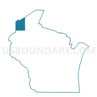
Outline

Summary
| Unique Area Identifier | 693532 |
| Name | SUMMIT - T 2 Voting District |
| County | Douglas County |
| State | Wisconsin |
| Area (square miles) | 83.39 |
| Land Area (square miles) | 83.14 |
| Water Area (square miles) | 0.25 |
| % of Land Area | 99.70 |
| % of Water Area | 0.30 |
| Latitude of the Internal Point | 46.43444510 |
| Longtitude of the Internal Point | -92.23741680 |
Maps


Graphs
Select a template below for downloading or customizing gragh for SUMMIT - T 2 Voting District, Douglas County, Wisconsin


Neighbors
Neighoring Voting District (by Name) Neighboring Voting District on the Map
- DAIRYLAND - T 1 Voting District, Douglas County, WI
- Holyoke Twp. Voting District, Carlton County, MN
- Nickerson Twp. Voting District, Pine County, MN
- SUMMIT - T 1 Voting District, Douglas County, WI
- SUPERIOR - T 2 Voting District, Douglas County, WI
- SUPERIOR - T 3 Voting District, Douglas County, WI
- Wrenshall Twp. Voting District, Carlton County, MN
Top 10 Neighboring County Subdivision (by Population) Neighboring County Subdivision on the Map
- Superior town, Douglas County, WI (2,166)
- Summit town, Douglas County, WI (1,063)
- Wrenshall township, Carlton County, MN (382)
- Dairyland town, Douglas County, WI (184)
- Holyoke township, Carlton County, MN (182)
- Nickerson township, Pine County, MN (167)
Top 10 Neighboring Unified School District (by Population) Neighboring Unified School District on the Map
- Superior School District, WI (33,892)
- East Central School District, MN (7,084)
- Webster School District, WI (5,524)
- Wrenshall Public School District, MN (1,830)
Top 10 Neighboring State Legislative District Lower Chamber (by Population) Neighboring State Legislative District Lower Chamber on the Map
Top 10 Neighboring State Legislative District Upper Chamber (by Population) Neighboring State Legislative District Upper Chamber on the Map
Top 10 Neighboring 111th Congressional District (by Population) Neighboring 111th Congressional District on the Map
Top 10 Neighboring Census Tract (by Population) Neighboring Census Tract on the Map
- Census Tract 704, Carlton County, MN (7,822)
- Census Tract 303, Douglas County, WI (5,066)
- Census Tract 302, Douglas County, WI (5,027)
- Census Tract 9501, Pine County, MN (2,493)
Top 10 Neighboring 5-Digit ZIP Code Tabulation Area (by Population) Neighboring 5-Digit ZIP Code Tabulation Area on the Map
- 54880, WI (30,772)
- 54830, WI (2,752)
- 55797, MN (1,441)
- 54836, WI (1,080)
- 55712, MN (586)
- 55749, MN (449)